-lw-scaled.png.png)
The Ultimate Guide To Climbing Adam's Peak (Sri Pada): Sri Lanka's Most Sacred Mountain
When we’re travelling, it’s always difficult for us to resist the allure of mist-shrouded mountain peaks. They have a magnetic pull that draws us to them, like few other things on this Earth.
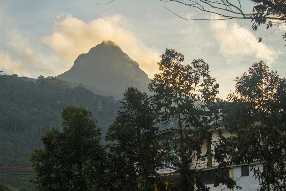
It was while travelling in Sri Lanka, that we first heard about the world famous Adam’s peak; a steep, conical-shaped mountain in Sri Lanka’s central highland region that soars above all the surrounding hills and puts them all to shame with its lofty grandeur.
But Adam’s peak is a lot more than just a physically imposing mountain.
It’s also a famous pilgrimage site for Buddhists, Christians, Muslims and Hindus and every year, thousands of religious devotees make the ascent to pay homage to a sacred relic at the summit that they believe has colossal significance to their particular religion.
The word ‘famous’ is perhaps an understatement here. In fact, no other mountain on our planet has been revered by so many people, from so many different religions, for as many centuries as Adam’s peak has. It is truly a marvel of our world.
Adam's Peakfacts
Adam’s peak is a steep-sided, conical-shaped mountain that reaches a maximum altitude of 2,243 metres above sea level. It was once believed to be the highest mountain in Sri Lanka but it is now known to be the 4th highest mountain in the country.
The mountain has a remarkable profile, which looks very much like that of a stratovolcano and it stands out dramatically from all the other mere hills that surround it on all sides.
The mountain is an important watershed for Sri Lanka's four main rivers, including the country's longest river, known as the Mahaveli Ganga. The sources of all these rivers are found on the lower slopes of the mountain and are fed by the abundant rains that fall upon it.
The location
Adam's peak is located in the southwestern corner Sri Lanka’s central highlands, in Sabaragamuwa province. To be more precise, it’s found about 40km northeast of the city of Ratnapura and 32km southwest of the city of Hatton.
Religious Significance of Adam's Peak
Adam's peak is a visually impressive mountain on account of its steepness and loftiness but that is not the reason why it is so revered by followers of so many religions.
The mountain in fact owes its sacred status to an indentation shaped like a footprint that is found in a boulder at its rocky summit.
The mountain also displays some unusual optical effects, which only reinforces the pilgrims' belief that it is no ordinary mountain and which they inevitably link to this mysterious 'footprint'.
The explanation for the origin of the footprint depends on what particular religion you're dealing with.
Most of the Sinhalese people of Sri Lanka are Buddhists and they believe the indendation to be a genuine footprint left by Lord Buddha when he visited Sri Lanka.
Muslims also believe the rock formation to be a footprint but not one left by the Buddha. They believe it is the footprint of Adam, created when he took his first step on Earth after having been exiled from the Garden of Eden.
The Portugese Christians can't seem to agree whether the footprint was left by Adam, St.Thomas or the Eunuch of Candace, Queen of the Ethiopians.
Hindus of South India believe the formation to be the footprint of their God Shiva and refer to the mountain as Shiva Padam,which means 'Shiva’s foot' in the tamil language.
Even a 15th century Chinese work says the footprint was made by Pwan-Ko, the primordial man or the first man to have existed in Chinese mythology.
In reality of the course, the footprint is just a natural indentation in the rock, carved out by the elements over time.
In fact, if the indentation was not associated with a pilgrimage tradition or pointed out to you as a footprint, you would never recognize it as one. As Lieutenant Malcolm in said of the footprint on his visit to Adam's peak in 1815, ''It requires a great deal of imagination to trace it out.''
This obvious truth however doesn’t stop 20,000 pilgrims from climbing the 5,500 steps to the summit of the mountain every year to worship the footprint.
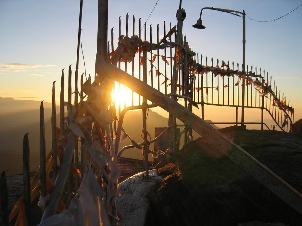
The goal of most pilgrims is to reach the summit of the mountain for the sunrise, where they can pay homage to the footprint and witness some incredible optical illusions, some of which they mistakenly associate with the legendary footprint.
Once such effect is the appearance of several images of sun before the sun itself has actually risen above the horizon, a kind of optical illusion caused by the phenomenon in physics known as‘total internal reflection’.
Light rays from the sun that has not yet risen above the horizon get reflected like a mirror when they reach the boundary between the dense air near the Earth’s surface and the less dense air higher in the Earth’s atmosphere. Several different images of the sun thus reach the viewers atop the mountain before the real sun emerges.
Although it’s an atmospheric phenomenon, the pilgrims interpretation of the whole event is that the sun is coming up several times to worship the footprint of the Buddha before descending back down again.
Another interesting phenomenon that can be witnessed from Adam’s peak at sunrise is the almost perfectly symmetrical triangular shadow of the mountain that appears to almost hang suspended in mid-air below. The shadow then moves gradually downwards as the sun rises.
A brief history of Adam's Peak
Many believe that King Valagambhu was the first to discover the footprint at the mountain summit in the 1st century BCE. The king had been exiled from his throne to the forest wilderness for 14 years and had been led to the mountain summit by a deity disguised as a stag, where he stumbled across the footprint.
The historical accounts suggest that Adam’s peak has been paid homage to by pilgrims and royalty alike, from a great variety of countries and religions, for at least a thousand years.
How then did the mountain become so widely known, at such an early period in history?
Well, you have to consider that in ancient times, Sri Lanka lay right on the main sea route linking east to west, the so-called silk road of the sea.
Thus, from 300-500 CE onwards, many Indian, Chinese, Arabic and later European traders, monks and missionaries would stop by in Sri Lanka when travelling to and from each other’s countries, to see the island’s many shrines.
The famous Moroccan explorer Ibn Battuta climbed the mountain in 1344 CE and he called it ‘Serendib’. He says that the mountain was visible to ships from far out at sea and it is true that Adam’s peak can be seen above the horizon nearly 80 miles before the coastline comes into view. In one of his accounts he remarks:
‘WHEN we sailed, however, the wind changed upon us, and we were near being lost; but arrived at last at the island of Ceylon, a place well known, and in which is situated the mountain of Serendib. This appeared to us like a pillar of smoke, when we were at a distance of nine days from it.’’
The earliest reasonably accurate account of the mountain by a European was left by Marco Polo, the Venetian merchant traveller. Marco Polo did not climb Adam’s peak but this is what he had to say:
‘"In this island there is a very high mountain, so rocky and precipitous that the ascent to the top is impracticable, as it is said, excepting by the assistance of iron chains employed for the purpose. By means of these some persons attain the summit, where the tomb of Adam, our first parent, is reported to be found. Such is the account given by the Saracens. But the idolaters assert that it contains the body of Sogomon Barchan ( Sakyamuni Buddha), the founder of their religious system, and whom they revere as a holy personage".
It appears that before the modern era, climbing Adam’s peak was a far more arduous undertaking than it is today.
There were no steps installed in the steep upper reaches and pilgrims had only chains to hold onto that were probably first installed by a Sinhalese King. The chains can in fact still be seen today, on the Ratnapura trail of the mountain, which was the main route to the summit for over a thousand years.
The final ascent was not only incredibly difficult but also very dangerous, as many pilgrims were blown off the mountain to their deaths by strong gusts of wind.
The trail to the summit was also not lit by electric lighting in the past, as it is today. Pilgrims had to carry candles, hurricane lanterns or burning torches for light when walking the trail at night.
The mountain of many names
Given the history of Adam's peak and the diversity of people, religions and cultures that have interacted with the mountain, it's unsurprising that the mountain has a plethora of names associated with it.
The Sinhalese know it as 'Sri Pada', which means 'sacred foot' and this is the most common name in use today.
In the Mahavamsa, the great Sri Lankan chronicle written in the 5th century CE, the mountain is known as ' Samantakuta' (Samanta's abode), which refers to a local deity called Samanta or Saman, that was originally believed to inhabit the mountain before buddhism reached Sri Lanka.
In modern day Sinhalese it is often called ‘Samanelakhanda’ which may either be a reference to the deity Samanta or it may refer to the butterflies (samanalaya) which visit the mountain each year during their annual migration.
The Tamil's of South India refer to it as 'Svargarohanam' (the ascent to heaven) or 'Shiva Padam' (Shiva's foot).
The Portugese called it Pico de Adam and the English 'Adam's Peak'.
In Sansrkit literature the mountain is known by various other names including Mount Lanka, Ratnagiri (mountain of gems), Malayagiri or Mount Rohana.

The six routes to the summit
In ancient times, the mountain could only be approached from Ratnapura (city of gems), but paths were later developed from Uva and Kehelgamuva. These two paths ceased to be used around 100 years ago and little trace of them remains today.
Nowadays, there are 6 known 'nodes' or starting points for those who wish to climb to the mountain summit, namely the Hatton-Nallathanniya, Ratnapura-Palabaddala, Kuruwita-Erathna, Murraywatte, Mookaywatte and Malimboda nodes.
In practice, many of these routes are rarely used and the most popular base for pilgrims and travellers alike is the tiny village of Nallathanniya on the Hatton side. This route is shorter than all the others by at least 5km although it is the steepest.
The Ratnapura-Palabaddala trail is the second most popular route and
more adventurous travellers might attempt the climb starting from Palabaddala or even descend to Palabaddala after climbing from Nallathaniya like many of the pilgrims do.
For the rest of this guide, we will deal with the highly popular Nallathaniya trail and give you all the information you need for this particular route.
Getting to Nallathaniya (trailhead for Adam's peak)
Nallathaniya (Dalhousie), the starting point for climbing Adam's peak, is best reached from Hatton. You can take a bus from the main bus stand in Hatton to Nallathaniya via Maskeliya. If there are no direct buses, you will have to first reach Maskeliya and then take a bus from there to Nallathaniya.
The total distance from Hatton to Nallathaniya is about 32 km and from Hatton to Maskeliya is 20km. The journey from Hatton to Nallathaniya takes about 2 hours and should cost around 80 LKR.
Be prepared for a journey through scenic surroundings but hang on for your life at the sharp bends. The Sri Lankan bus drivers have a reputation for being pretty reckless.
Getting to Hatton:
Hatton is on the main Colombo-Kandy-Nuwara Eliya railway line so you can get to Hatton by train from any of these major centres.
It's also possible to take a bus from the main bus stands in Kandy or Colombo to Hatton, although the journey by road will not be as smooth or as scenic as the journey by rail.
Accommodation in Nallathaniya
There is a decent range of accommodation options in Nallathaniya and along the main road leading into the village.
During the off-season, vacant rooms will be very easy to find and booking shouldn't be necessary. Prices will be much lower at this time too with double rooms starting as low as 1,000 LKR.
This was actually the price we paid at our hotel, the Adam's Peak Inn which is found directly adjacent to the much more popular Daddy's Guest house.
During the pilgrimage season, room rates will likely skyrocket and it may be very difficult to find a room. You would be wise to book in advance if you're planning to climb Adam's peak during this period. You can book here.
When to climb Adam's peak
The pilgrimage season officially runs from the full moon (poya) day in December (Unduwap poya festival) to the full moon (poya) day in May (Vesak Poya festival).
If you want to climb during the season, avoid the weekends, times around full moons and avoid the first week of the Sri-Lankan new year (in mid-april) because at these times the trail will usually be jam-packed with thousands of pilgrims and the queues are often so long that many people never reach the summit.
Outside the pilgrimage season (June-November), conditions for climbing the mountain are less favourable, with more chances of rain, heavy mist and bad weather, but you at least won’t have to put up with suffocating crowds of fanatical religious pilgrims.
The route from Nallathaniya (Dalhousie)
Know what's involved
Depending on your fitness level, the climb to the summit will probably take you anywhere between 3 and 7 hours. It took us about 3.5 hours but we were moving quite quickly.
The total distance to the summit from the village is around 7 km and the elevation gain is about 1,000 vertical metres, starting from 1,252 m at the trailhead and ascending to 2,243 m at the summit.
If you’re hoping to see the sunrise at 6 a.m, you’ll need to set out from Nallathaniya around midnight or 1 a.m and you should bring plenty of warm clothes because waiting for the sunrise in the darkness on an exposed mountaintop can be a chilling experience.
What To Bring:
During the pilgrimage season, the route to the summit is illuminated with electric lights and the wayside is lined with refreshment stalls and kiosks.
However, if you go in the off-season like we did, everything will be dead and pitch dark at night, so you had better bring your own supply of food, water, rain-gear, spare warm clothing and lighting (headlamp or flashlight) for the trek.
If you have bad knees, take trekking poles as well because 5,500 steps is no laughing matter.
You don’t really need hiking shoes to climb Adam’s peak because the entire route from Nallathaniya has been tamed and is paved with concrete steps and rough stones. Pilgrims seem to have no trouble climbing the mountain in bare feet so ordinary shoes should work just fine for most people.
Be warned that leeches can sometimes be a problem when climbing the mountain. Every year at the start of the pilgrimage season the vegetation encroaching upon the trail is cut back to keep the ravenous leeches at bay and long ago, pilgrims would have carried lemons to ward off the leeches.
We actually didn't have any issues with leeches but we were well prepared just in case, with a little bag of salt and a small tub of special citronella-based balm that you can buy for pennies in various shops in Nallathaniya.
You can also protect yourself by covering up; wear long pants and tuck them into your socks. Rub liberal amounts of salt into your socks and the lower regions of the pants too. If you get overheated and change into shorts, apply the citronella balm to the skin on your ankles and legs.
Another effective deterrents for leeches is tobacco. If you want to go to extremes you can soak your socks in tobacco-impregnated water or buy a pair of special leech socks (normally worn for rainforest trekking), although chances are, you won't encounter any.
A description of the route
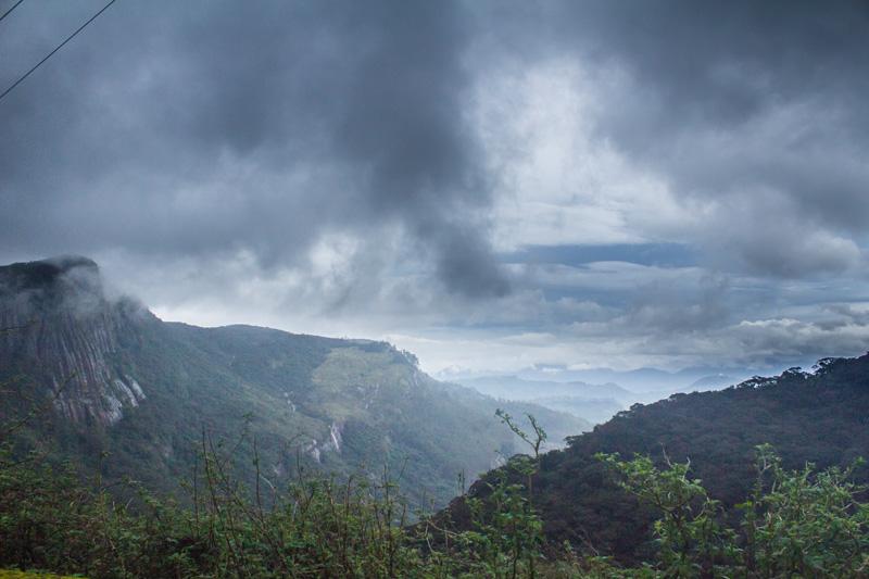
We climbed Adam’s peak in the off-season, in the month of July. The weather was unpredictable during our visit, with frequent rain showers and heavy fog blanketing the mountain much of the time.
Knowing there was little chance of a clear sunrise, we decided one misty morning to just set out from Nallathaniya (Dalhousie) and try to climb to the summit and then descend back down the mountain to the village before nightfall.
After leaving Nallathaniya, the hike begins to ascend very gradually, passing by a number of kiosks, tea houses, massage parlours, shrines, temples and numerous danasalas or refuge centres offering shelter, medical assistance and sometimes food and water to pilgrims. This area was pretty dead when we visited however since it was the off-season.
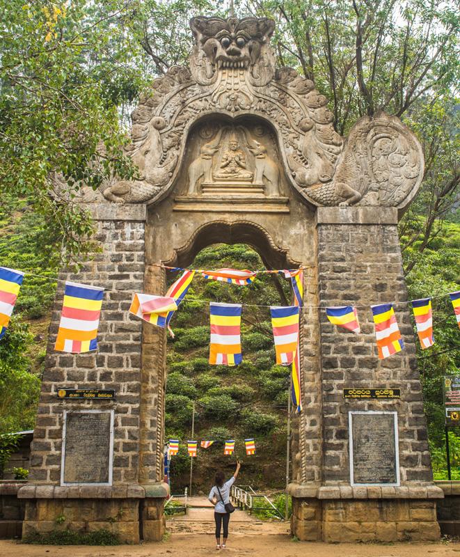
The first thing we found noteworthy near the start of the hike was a beautiful arched stone gateway called the 'Makhura gateway', which marks the beginning of the ascent proper.
The gateway bears numerous carved figures and a finely carved kala motif at its pinnacle. Kala is a ferocious, jawless monster from Hindu mythology that symbolizes time.
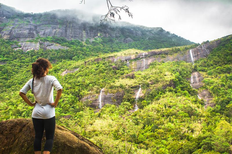
After passing through this archway, the trail passes alongside a tea plantation on the left hand side and a lush green valley on the right, eventually bringing you to a viewpoint with several stunning waterfalls:
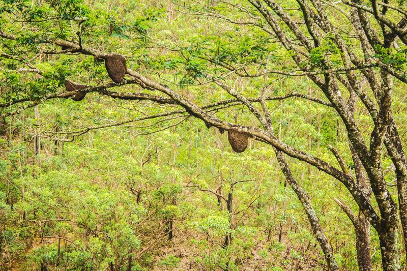
We also spotted a cluster of free-hanging beehives in this same valley, suspended from a tree branch. These semi-circular structures are the homes of wild bees.
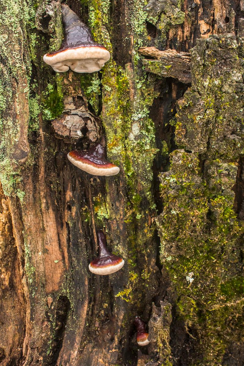
Trees by the wayside sport interesting fungi and there was one particular tree that caught our attention. It had several bracket fungi growing from its trunk, which we believe may have been young specimens of the red-banded polypore (Fomitopsis pinicola).
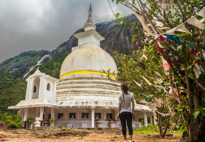
The trail continues on from here and about 2km into the hike, you reach the foot of a staircase that ascends to a plateau with a Japanese peace pagoda.
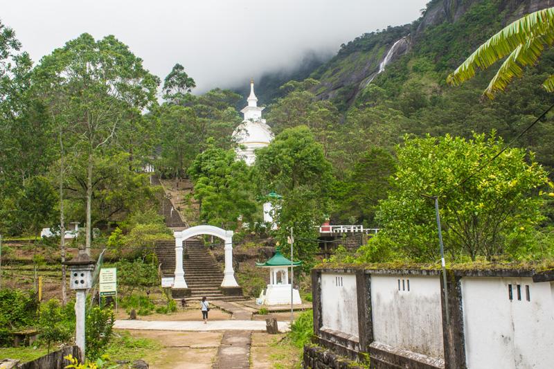
This Japanese peace pagoda is called the Sama Chatiya and was built by the famous Japanese Buddhist monk Ven Nichi Fuji in 1976. The pagoda is maintained by a group of Japanese monks.
There are several other Japanese peace pagodas in Sri Lanka, although the only other one we visited was the one near Galle in the south. If you attempt the climb of Adam's peak at night, you can get a good look at this on your descent in the daylight.
Beyond the peace pagoda, the trail intensifies slightly, although the steps are still not particularly steep at this point. You’re now entering the peak wilderness sanctuary, although you probably wont experience the sense of wildness if you climb during the pilgrimage season.
The peak wilderness sanctuary is the third largest (by area) of the 50 wildlife sanctuaries in Sri Lanka, covering an area of 224 sq. km and mostly consisting of misty rain forest.
The forest here features giant trees with mosses that hang from the branches, rhododendrons that display beautiful red blossoms and rare orchids that grow from the moist, loamy soils.
An information sign beside the trail tells us a few of the inhabitants of this sanctuary.
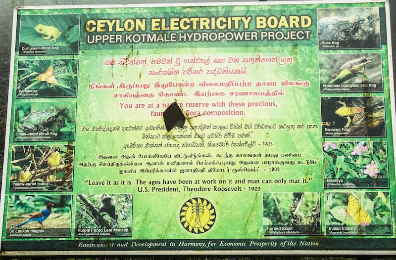
An interesting quote by Theodore Roosevelt is written on the information sign, which was originally a reference to preserving the wildness of the Grand Canyon in Arizona but is equally applicable to all natural treasures:
''Leave it as it is. The ages have been at work on it and man can only mar it.''
We would have to agree with Mr. Roosevelt on this one. The sign tells us that the sanctuary supports the beautiful Ceylon magpie (Urocissa ornata) and the purple-faced langur (Trachypithecus vetulus), which are two species endemic to Sri Lanka. The sign also displays various butterflies, birds, lizards, wildflowers and several species of frog.
In fact, the world's rarest species of toad Adenomus kandianus was rediscovered in this very sanctuary in 2009, after it was believed to be extinct for 133 years.
We didn't see any wildlife during the climb unfortunately, although we can probably partially blame that on the dismal misty conditions.
Anyhow, after gaining considerable altitude by ascending these concrete steps, we eventually stopped for a moment to take in the view of our surroundings. We noticed that the peace pagoda had become quite small and now looked rather insignificant from our new vantage point. We were definitely making progress.
As the trail continues to ascend, there are a few rest stops and a bridge crossing a small stream called the Seetha Gangula, where you can refresh yourself if the weather is warm, although the water will probably be icy cold.
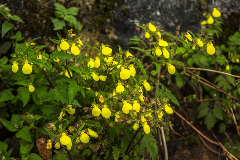
Keep an eye out along here for the beautiful lady’s purse or slipper flowers of Calceolaria tripartita. These flowers are shaped like a little pouch and have an incredibly vibrant yellow colour.
After passing the bridge, the climb starts to intensify and you'll face a stretch of almost non-stop climbing up concrete steps and a few sections with rough stones that have been partly washed away.
As you ascend higher and higher, a certain point called 'Indikatapuna' is reached where the trail suddenly begins to ascend very steeply.
This section of the trail is known as 'Mahagiridamba' or 'the great rock climb' and it continues for about 750m to the summit. You'll notice that the individual steps become much steeper and a metal handrail is now available on both sides to help take some of the burden off your now aching legs.
From this point onwards, it’s a joint effort between your arms and your legs, working together in unison to haul you up the mountain.
Your leg muscles will probably be burning from the lactic acid at this point but you just have to embrace the burn and keep taking it one step at a time. Keep your mind focused on the prize and push through the suffering.
‘If you’re going through hell, keep going.’ – Winston Churchill
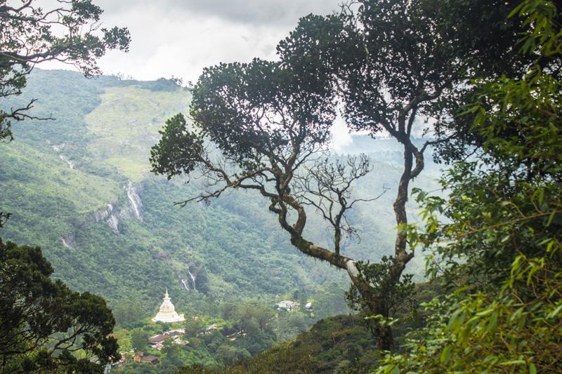
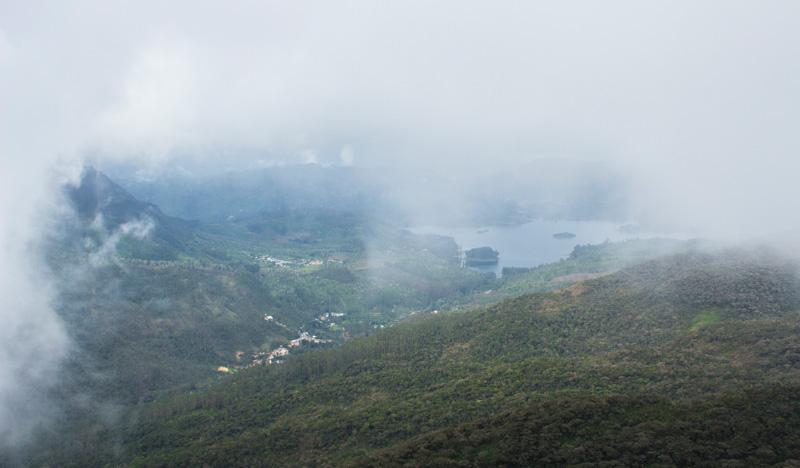
Every so often, make sure to take a breather and admire the view of your surroundings on the way up this steep section. It was during this part of the climb that the mists cleared momentarily and gave us a brief glimpse of the landscape below:
About 45 metres before the summit, there is an interesting cave called 'Bhagava cave' just off to one side of the trail.
The cave acted as a place of refuge for pilgrims caught on the mountain during bad weather and also a place where ascetic monks would live for 9 months of the year, subsisting only on the fruits of the land.
There are two interesting inscriptions inside the cave, one written by King Nissanka Malla during his visit to Adam's peak in the 12th century and the other written in Arabic, praising Mohammed.
The summit
If you have the strength and the stamina to persevere through this final steep section, you will eventually find yourself at the summit, at long last.
When we reached the summit, the entire area was completely shrouded in a thick fog and it was rather chilly and windswept.
Visibility was almost nil but a lone Buddhist monk dressed in a vibrantly coloured orange robe emerged from the mist and he greeted us as we walked up the final steps to the highest platform where the footprint is found.
If you were to reach the summit platform in fine weather, you would see something like this:
.jpg)
This temple you see here is literally built into and wrapped around the rocky summit of Adam's Peak. It features a shrine to Samanta (the mountain deity) and right next to it is the shrine over the sacred footprint.
We are unable to view the footprint because the door to the shrine is locked during the off-season and doesn’t get opened until the pilgrimage season begins.
Different visitors throughout history have given widely differing descriptions of the dimensions of the footprint so we can't rely on any those accounts for accuracy.
Judging by the images on the web, the dimensions of 5' 7''x 2' 6'' sound about right.
Walking around the temple building we noticed an interesting sign:
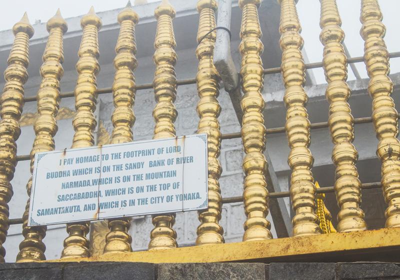
''I pay homage to the footprint of Lord Buddha which is on the sandy bank of river Narmada, which is on the mountain Saccabaddha, which is on the top of Samantakuta and which is in the city of Yonaka.''
It would appear then that Lord Buddha left more than one footprint during the course of his travels. Of course 'Samantakuta' here refers to Adam's peak, which was believed to be the abode of the local mountain deity Samanta before buddhism reached Sri Lanka.
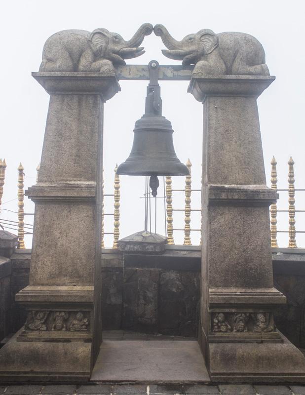
If you wander around the upper platform, you'll surely notice the belfry with the bell that pilgrims will traditionally ring with one knell for every time the pilgrim has climbed the mountain.
Some pilgrims ring the bell more than 20 times.
Up here before dawn during the season, pilgrims gather on the east side awaiting the sunrise. When the sun emerges above the horizon, the pilgrims then all move to the west side to view the amazing triangular shadow of the mountain that slowly recedes into the foot of the mountain and then vanishes.
As for the views from the summit we can't give an opinion because the fog was impenetrable during our brief stay at the top. It didn't show any signs of lifting any time soon so we decided to leave and descend back down.
Many people say that although Adam's peak is not that high in absolute terms, it gives an impression of exceptional loftiness due to it's steep sides and the many lower mountains that surround it.
The Irish-born British politician and traveller James Emerson Tennent has a wonderful description of the sweeping views from Adam's peak, that sums it all up:
"The panorama from the summit of Adam's Peak is perhaps the grandest in the world, as no other mountain, although surpassing it in altitude , presents the same unobstructed view over land and sea. Around it, to the north and east, the traveller looks down on the zone of lofty hills that encircle the Kandyan kingdom, whilst to the westward the eye is carried far over undulating plains, threaded by rivers like cords of silver, till in the purple distance the glitter of the sunbeams on the sea mark the line of the Indian Ocean"
The descent went a fair bit quicker for us than the ascent, although as every hiker knows, it's the descent that tends to wreak the most havoc with your knees. We didn't have any knee problems though thankfully and we half-walked, half-ran down the 5,500 steps, in our attempt to get back to the village before night fall.
It was just getting dark around 6 p.m as we finally neared Nallathaniya village, using our headlamps to see us through the last kilometre or two of the journey back to the village.
All-in-all, the hike took us about 7-8 hours and we were pretty exhausted but feeling happy and accomplished. No doubt our legs would be sore in the morning.
Watch Video:
We covered Adam's Peak in our Kandy video. If you just want to see the section where we climb Adam's peak, skip to 4:20 in the video.
Recommended Guidebook: Lonely Planet Sri Lanka
If you found this guide useful please share it and leave us your feedback below. Have you ever climbed Adam's peak? If so, we'd love to hear about your experience.

JOIN OUR LIST
SUPPORT US
FOLLOW US
ABOUT US
Our names are Eoghan and Jili and we hail from Ireland and India respectively.
We are two ardent shoestring budget adventure travellers and have been travelling throughout Asia continuously for the past few years.
Having accrued such a wealth of stories and knowledge from our extraordinary and transformative journey, our mission is now to share everything we've experienced and all of the lessons we've learned with our readers.
Do make sure to subscribe above in order to receive our free e-mail updates and exclusive travel tips & hints. If you would like to learn more about our story, philosophy and mission, please visit our about page.
Never stop travelling!
FOLLOW US ON FACEBOOK
FOLLOW US ON PINTEREST
