-lw-scaled.png.png)
The Ultimate Guide To Cherrapunji: Discover Spectacular Waterfalls & Living Root Bridges
The northeastern states of India are only connected to mainland India by a narrow bottleneck called the Siliguri corridor or chicken’s neck. Most of these so-called ‘seven sister states’ are still relatively unexplored and there is little written about them compared with most Indian states.
Destinations that are relatively uncharted and little explored always lure us like moths to a candle and in the summer of 2015, we travelled to Cherrapunji in Meghalaya state to:
- witness the locality's spectacular waterfalls
- trek in the lush, untouched, forested river valleys
- explore the labyrinthine cave systems
- last but not least, investigate the famous living root bridges - marvels of engineering that the indigenous people of the region have used for centuries to cross swollen rivers during the monsoon season.
These experiences had a profound and lasting impact upon us, and now we wish to share all the important details of our trip with you, so that you can easily plan your trip of a lifetime to this paradise on Earth.
Location
Cherrapunji is a small town found in Meghalaya state in northeast India. It's located about 54km southwest of Shillong, the state capital.
The town is situated high atop the Shillong plateau, in the East Khasi hills. This plateau averages about 1,480 m above sea level and lies as much as 1,000 m above the floors of the surrounding valleys. The town itself sits at an altitude of 1,260 m above sea level.
The plains of Bangladesh begin only about 25km south of the town but the nearest border crossing into Bangladesh at Dawki can only be reached by an 85km drive, due to route the road takes.
Getting there
Most travellers will come to Cherrapunji from Shillong. The best thing to do is to take a shared Tata Sumo (MUV) from the sumo stand in Bara Bazaar in Shillong. Ask locals to point you in the right direction. On google maps it’s marked as Lewduh Bus station. There is no timetable for the departures but rather the vehicles leave when full with people.
Where To Stay
There isn’t a huge range of budget accommodation options in Cherrapunji but there are a couple of gems if you know where to look.
We opted to stay in By The Wayguesthouse, which is a great budget option (much cheaper than the homestays in Cherrapunji, which will set you back 1,500 - 2,000 INR) and the guy who runs this place is quite interesting too.
Here you can stay in either of two private bungalow rooms that are set back from the main road, for just 500 INR per night.
If you want to book accommodation in Cherrapunji online, you can use the search box below to see what deals are currently available.
Some background info about Cherrapunji
The term ‘Meghalaya’, given to the Indian state that Cherrapunji is found in, means ‘abode of the clouds’ and the name is very apt for this mountainous state, which is so often shrouded in mist.
The town of Cherrapunji has been renamed back to its original name of ‘Sohra’ by the state government. The British pronounced this ‘churra’ and eventually the name Cherrapunji evolved from this, which was actually first used by tourists from other parts of India and it means ‘land of oranges’.
Climate
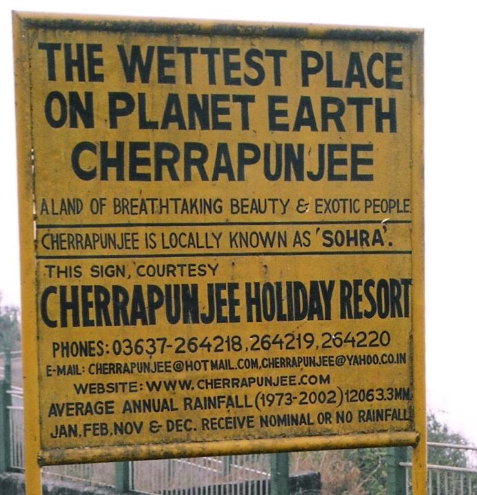
The town of Cherrapunji is often credited as being the wettest place on Earth but nearby Mawsynram, just 10 miles to the west receives even more rainfall than Cherrapunji according to the Guinness Book of World Records. Mawsynram’s average annual rainfall has been recorded at an incredible 11,871mm.
However, Cherrapunji does hold several other rainfall records including the record for the highest annual rainfall total, where in 1861 it received a staggering 26,470mm of rain. It also holds the two-day rainfall record, where on 15 to 16 June 1995, it received an unbelievable 2,493 mm of rain.
Two places in Columbia have also laid claim to the title of ‘wettest place on Earth and one of those is a town called Puerto Lopez, at the foot of the northern Andes Mountains. Unfortunately, Puerto Lopez is said to be missing data for several months in the middle of its 50 years of rainfall recording, meaning that the records can’t be accurately compared to those of other places. Another town that claims the title is Lloro, in northwestern Columbia. However, Lloro’s rainfall measurements were made using outdated gauges so they can’t be relied upon.
Most of the rain that Cherrapunji receives is monsoonal and of the orographic type. Moisture-laden southwesterly winds from the Bay of Bengal blow across the plains of Bangladesh where they’re forced to rise upon meeting the windward side of the Khasi Hills. The vapour-laden air cools and condenses into rain-bearing clouds.
Despite all the rainfall it receives, the town has been ironically experiences water shortages in recent years and residents now have to trek long distances to obtain potable water. They have also had to learn how to harvest and store rainwater and some families now have to purchase water carried in by large trucks. But how on Earth can that be possible? Well, there are a few possible reasons for why this happening.
The first possible reason is climate change. The total volume of rainfall has decreased in recent decades, with Cherrapunji now receiving on average about one third of the annual rainfall it received back in the 1970s.
Also, in recent years, rainfall hasn’t been consistent year-round in Cherrapunji and between the months of November-March, there have been serious drought periods. Rainfall has also generally become more erratic and unpredictable. Another recent trend is localized rainfall, with one locality sometimes receiving plenty and another receiving very little. This was apparently not the case in the past, when Cherrapunji received year-round, consistent and more predictable rainfall.
The second major reason for the problem has to do with the dramatic population increase in Cherrapunji over the last few decades, putting more pressure on the limited water resources, especially during the drier months. In 1971, the population was only about 7,000 but now there are over 100,000 people living in the area.
Local people deny that deforestation or industrialization are to blame, because they say that there never were any large forests around Cherrapunji and what small groves of trees existed they considered sacred and protected them. Also, the only major industry near the town is a cement plant so that can’t be playing a major role.
Another aspect of Cherrapunji’s climate is the cooler weather, due to the relatively high altitude. Average temperatures in January are 11.5°C and still a fairly mild 20.6°C in August with an annual mean of 17.3°C.
Environment
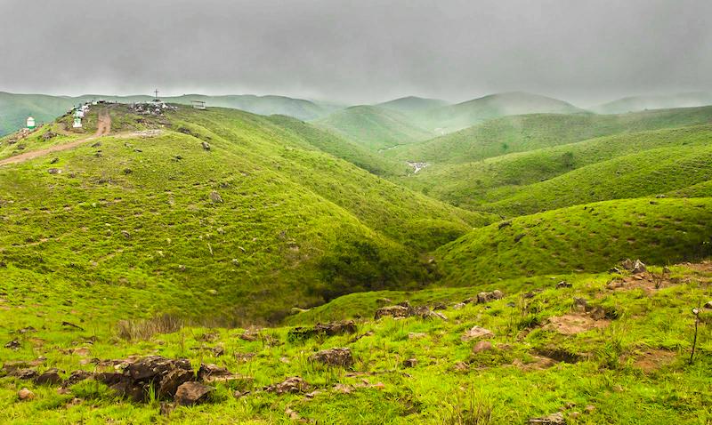
The landscapes of the Shillong plateau are almost completely deforested and could be described as a bleak but lushly green, grassy moorland habitat. Farming is impossible here due to the wet climate, so all the produce is imported from drier areas.
The term ‘Scotland of the East’ was originally given by European settlers to the rolling hills around Shillong to the North because the landscapes reminded them of home, but the term is equally valid in its application to the deforested landscapes around Cherrapunji. Despite all the rain, many of the plants here are actually xerophytic (require very little water), to cope with the drought periods in the winter months.
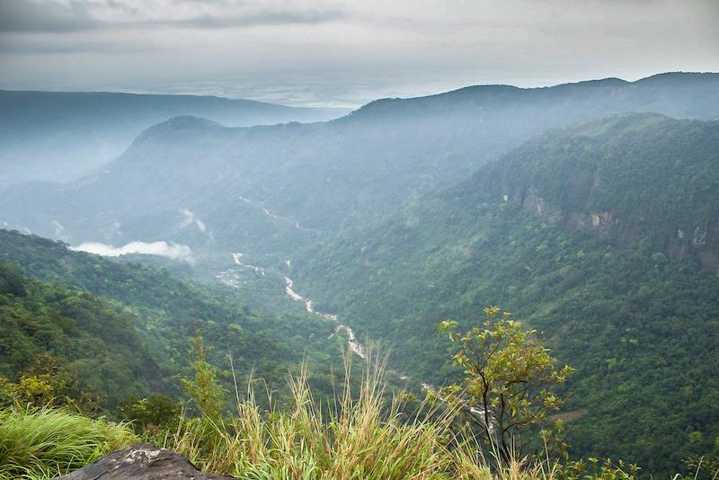
Although the Shillong plateau may be deforested, the valleys that lie below it are quite the opposite, cloaked in lush, green forests and retaining a raw wilderness character. Many rivers carry rainfall towards the edge of the plateau, forming numerous spectacular waterfalls as the water flows over the precipice and tumbles down into the deeply cut valleys below, before being carried away to the plains of Bangladesh.
The rains also carve fascinating caves out of the limestone rocks in the area and Meghalaya state is known to have over 1,500 of them, of which only about 980 have been explored and many of these only partially. Of the 10 longest caves in India, 9 are found in Meghalaya and this state has the longest cave in all of India, known as Krem Liat Prah. With over 31 kilometres of explored length, Krem Liat Prah is also one of the longest caves in the entire world.
The biggest threat currently facing these incredible caves is limestone mining for the cement industry and conserving them is very important, as many provide habitat for many rare species of bats and other poorly understood creatures.
People
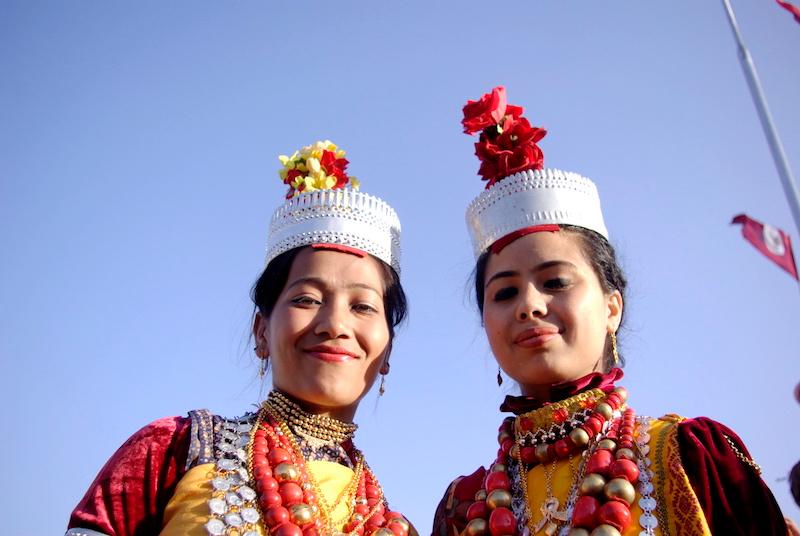
The people of Cherrapunji are known as the Khasis and they number about 1 million in total in the state of Meghalaya. Their culture is matrilineal, which is a system where the women have a dominant role in daily life.
In Khasi society, the youngest daughter always inherits the property or if the couple has no daughter, they’ll adopt one and she'll then inherit the property. The youngest daughter also plays a pivotal role in educating and looking after her siblings, as well as her parents in old age.
Khasi children take the mother’s surname and the men once married have to live in the home of their mother-in-law and get bossed around by her (and their wife) all day. With no property, little security and no role in the family business, many Khasi men feel pretty powerless and useless. Many thus end up as alcoholics and die at a young age.
The reason for this system may have to do with the history of the Khasi people, where men were always away from the village for long periods of time, at war with neighboring tribes. The womenfolk thus developed a central role in raising the family.
However, Khasi women don't technically rule the society; in other words it’s not a matriarchal society. Their political power is limited. In the past for example, it was the son of the King’s youngest sister that would inherit the throne and in today’s world, women are minimally represented in village councils or panchayats.
.jpg)
Christianity has a strong influence over the Khasis, with about 85% identifying as Christians. The religion has played a role in the relatively high literacy rates of the people of Cherrapunji (74% vs the national average of 59.5%) but it has also somewhat diluted their indigenous culture.
Christianity was first introduced to Cherrapunji by Welsh missionaries, before later spreading to many other parts of the Khasi and Jaintia hills. In Nongsawlia, just 2km south of Cherrapunji town, you’ll find the Presbyterian Nongsawlia church, which was the first Christian church established here in the Khasi-Jaintia hills.
There are also many small Christian cemeteries dotted around the landscape, normally found atop small knolls, where you’ll find gravesites and stone Christian crosses that mark them.
Other notable monuments that are found throughout the length and breadth of the Khasi and Jaintia hills are the Khasi monoliths; horizontal stones on supports and vertical standing stones (menhirs) that have been erected by the Khasi people in honour of dead clan members or of those who have died heroically in battle. The vertical standing stones represent men, while the horizontal ones represent womenfolk.
One such cluster of monoliths can be found by the roadside on the way to Mawsmai cave. The largest and most impressive collection of these monoliths however is in Nartiang, which is found in the Jaintia hills, about 100km to the northeast.
To be able to work outdoors in the rainy climate of Cherrapunji, the people wear a somewhat comical-looking type of umbrella called a knup, made by sandwiching two layers of palm leaves between two loosely woven bamboo lattices.
Perhaps the most fascinating features of Khasi culture are its phenomenal living root bridges, which allow the people to safely traverse swollen mountain rivers in the monsoon season. Many Khasi people occupy remote villages that are hidden away inside the wild forests that cloak the lower valleys beneath the main plateau, and it is in here that you can find several of the famous living root bridges, which we’ll show you in more detail shortly.
The Layout
The accommodation in Cherrapunji is not all concentrated in one place, rather the various establishments are scattered haphazardly for several kilometres south of the town. There are a few decent local restaurants located at the T-junction just a few hundred metres to the south of the ‘By The Way’ guesthouse.
Waterfalls, waterfall viewpoints and caves are found both North and South of Cherrapunji town; there is one other cave (Arwah cave) just off the map to the north that we have not included on this map.
The living root bridges are found around the small Khasi village of Nongriat, which can only be accessed by descending down into the valley from Tyrna on foot, or by a much more longer and more challenging hike from Nokhalikai Falls.
Seeing the waterfalls of Cherrapunji
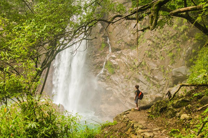
The waterfalls here in Cherrapunji are some of the most spectacular in the world and they include India’s highest plunge waterfall. We recommend you check out these 4 waterfalls: Nohkalikai Falls (highest in India), Nohsngithiang waterfall (seven sisters falls), Kynrem Falls and the remote Rainbow waterfall, which is impossibly beautiful and surreal.
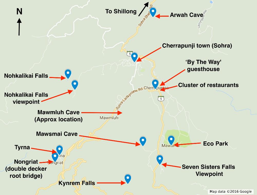
Nohkalikai Falls
Nohkalikai Falls is a spectacular cascade that plunges an estimated 340 metres from a lushly forested plateau down to a rocky green or often turquoise-coloured pool below. The best way to see this waterfall is from the Nohkalikai viewpoint, which is located 4.2 km from Cherrapunji town.
Getting there:
To reach the viewpoint for Nohkalikai falls you have to get onto the Nohkalikai road, by heading directly west from Cherrapunji town. It’s a bit of a mess of roads until you finally reach the longer uninterrupted road headed straight for the viewpoint. Ask locals to point you in the right direction if you get lost.
The waterfall can also be reached from the village Nongriat in the valley below, where the double decker root bridge is found. This is how we reached it. If you can imagine stumbling upon a waterfall like this after a challenging 1,000m of vertical ascent from the valley below…. that’s exactly how it was.
Additional Info:
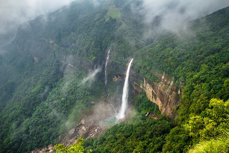
Being the tallest plunge waterfall in India, this is a pretty popular spot with domestic Indian tourists so it’s unlikely that you’ll have the viewpoint to yourself. There are a few snack stalls and souvenir shops around, selling various tribal handicrafts, wild jungle honey and other interesting products. We caved and bought a bottle of honey:
If you’re curious about the origin of the name, it means ‘the jump of Ka Likai’ in the Khasi language and there’s a grisly legend associated with the waterfall.
.jpg)
As the story goes, a woman called Ka Likai lived in a small village at the top of the waterfall with her beloved daughter and husband. One day her husband tragically died, forcing her to remarry.
While married to her new husband Ka Likai would work long days as a porter to earn money to support her family but whenever she returned home after work, she would give all her attention to her daughter and that made her new husband begin to grow jealous. This continued for a period of time until he finally cracked one day and killed the daughter, cooking her flesh but discarding her head and bones.
When the mother returned home that day, she noticed her daughter was missing and wanted to look for her. However, because she was tired and hungry, she sat down and ate the meal that her husband had prepared for her.
After the meal she went to prepare paan (Betel leaf and areca nut digestive aid) and that was when she found a severed finger of her daughter.
Realizing what had happened, the woman went mad with grief and ran outside the house while swinging a hatchet in her hand, eventually throwing herself over the edge of the waterfall nearby. Hence it’s now named after her.
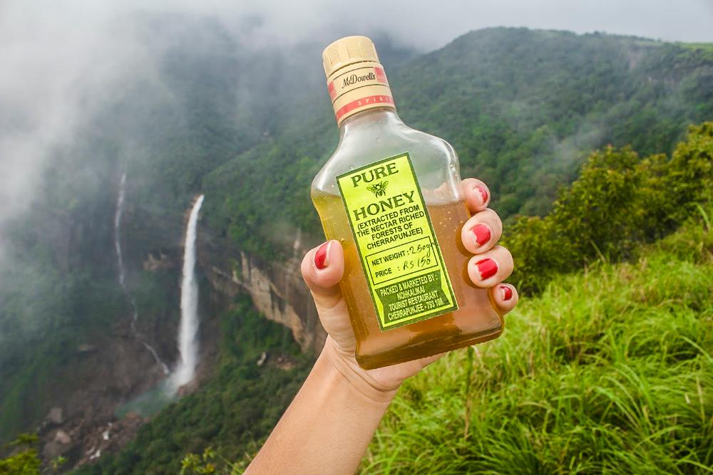
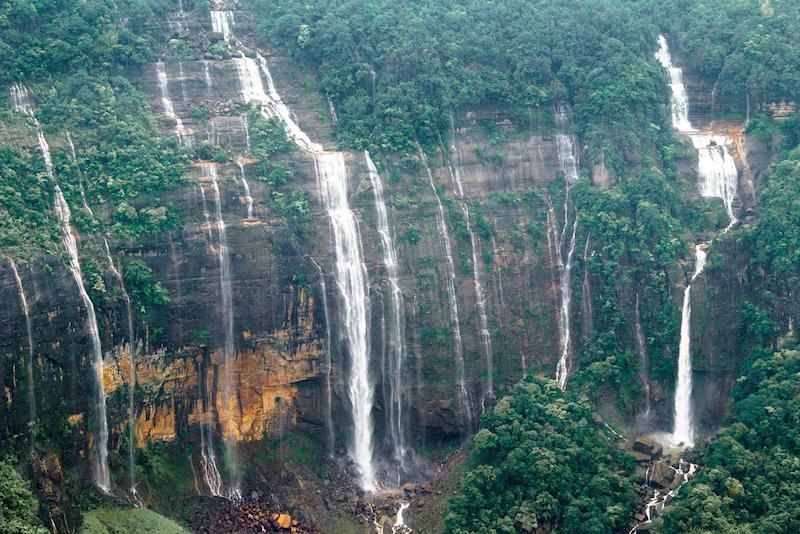
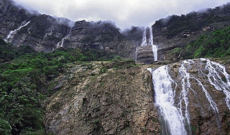
Nohsngithiang Waterfall
Also, known as the seven sisters falls, this is perhaps the most iconic waterfall of Cherrapunji. The seven-segmented waterfall tumbles down limestone cliffs from a height of about 315m, making it only slightly smaller than Nohkalikai Falls and still one of the tallest waterfalls in India. The seven segments get wider and almost merge to form a continuous curtain of falling water after heavy rains.
Getting there:
It’s actually possible to reach the top of this waterfall if you head to the Eco Park, located about 5km to the south of Cherrapunji town.
There are also several excellent viewpoints of the waterfall for which you just keep heading south past the Eco Park along the main road, until views of the waterfall start to appear on the left hand side. There are several good vantage points along here but the best one is at the 7 sisters falls view inn, located just off the main road, about 4.5km south of the town.
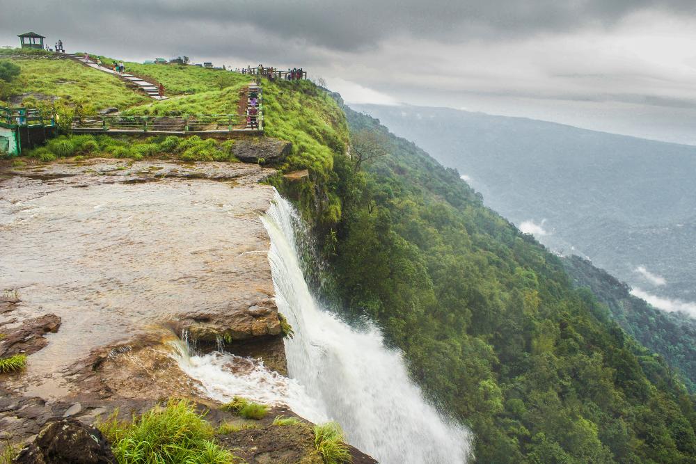
At the Eco Park, you can take a wander along the edge of the plateau and peer out over the edge at the falling water at a point where a river flows over the edge. This southern region of the park is the originating point of the Nohsngithiang Falls.
From up here, there are also some spectacular views of the valleys below and beyond to the Sylhet plains of Bangladesh when visibility is good.
The park is also famous for its vast variety of indigenous orchids, which were donated by the Shillong Agri-Horticultural society and are kept in the Green House.
It’s a very popular place with Indian tourists and they come in swarms because it has facilities that take the difficulty out of experiencing Cherrapunji. There are concrete pathways through the grassy habitat and also an arching concrete bridge spanning the main river that flows off the plateau.
Kynrem Falls
This is a spectacular 3-tiered waterfall with a height of 305 metres and the road runs right past it, crossing the river below the waterfall via a bridge. It’s located about 18.5 km from Cherrapunji town.
Getting there:
You just have to follow the main route 5 heading south from Cherrapunji. It heads south for about the first 12km and then starts to head west and then north for the last 4.5 km towards the falls.
Additional Info:
This is the 7th highest waterfall in India and is situated inside the Thangkharang park, another popular tourist spot in the area that’s famous for its rare orchids and plants.
Other than looking up at the waterfall from the road bridge, there are a few viewpoints of this waterfall from afar, which allow you to clearly see its three different levels. One of these is found a little ahead of the falls and there is also a view of it from the Thangkharang park, allegedly. We can’t give you more information on this because we didn’t visit this one, due to the difficulty in getting to it.
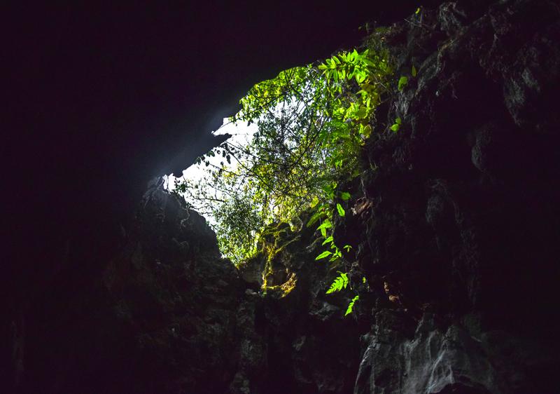
Seeing the caves
As we mentioned earlier, Meghalaya state has over 1,500 caves in total, but the two most accessible aves in the area around Cherrapunji are Mawsmai Cave, which is a show cave exclusively for tourists and the less visited but more interesting Arwah Cave, which only recently came into the limelight after being discovered by local men.
Another cave in the area is Mawmluh Cave, which is a very long, wild cave that’s much more challenging to navigate, meaning that tackling this will be somewhat of a mini-expedition.
Most of these caves support several species of bats (including some rare species) and also a variety of insects (centipedes, spiders, millipedes, beetles etc.) and crustaceans (copepods, freshwater crabs, crayfish etc.). Some caves even support the curious blind and albinic cave fish (Nemacheilus evazardi), an only recently discovered species, but they are only found in a few caves in Meghalaya.
Mawsmai Cave
This is a short limestone cave, about 150 metres in length, located 6.2km from Cherrapunji town and it’s very popular with domestic Indian tourists due to its accessibility and tourist infrastructure.
Getting there:
Mawsmai cave is easy to reach. Just follow the main road south from the town and take the right turn after about 5km. Take another right turn about 300m down this road and you should wind up at the cave.
Additional Info:
Since this is a very popular site with tourists, there are many shops and souvenir stalls outside, most of them selling a lot of useless junk.
There’s a small entrance fee of about 60 rupees here, as well as additional fees for cameras. As far as we can recall, the path from the cave exit meets the main path before you reach the ticket booth, so you can try avoiding the fees by heading down this path, entering through the cave exit and navigating the cave in the reverse direction. However, you might find it difficult to negotiate your way past the one-way flow of Indian tourists at the bottleneck sections of the cave.
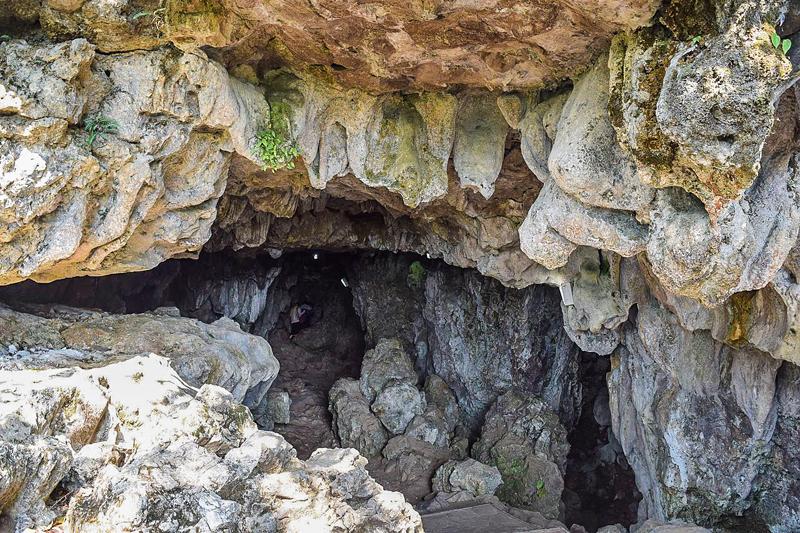
Not knowing about the path from the cave exit, we went ahead and bought tickets and did the cave in the normal direction. A path through the forest leads you to the cave entrance but just a short distance in we encountered a few bottlenecks, where the cave was completely blocked by slow-moving Indian tourists, making for long, frustrating delays.
However, once we got past the narrow bottlenecks near the beginning, we were able to proceed through the cave more swiftly. The cave is illuminated by electric lighting and wooden planks have been laid down to help people navigate the cave.
It was waterlogged in many places but never much more than ankle deep. A lot of water was also dripping from the cave ceiling and from the stalactites in many sections, so make sure you don’t mind getting a little wet.
There are a few interesting features like stalactites, stagmites, pillars etc. along the journey througoh the ave but nothing particularly mind-blowing.
Overall we’d have to say that we weren’t overly impressed with this cave, if we're to compare it to other caves we’ve explored in Southeast Asia. You eventually emerge from the cave through an opening at the far end and a path leads you from here back to the main entrance.
Arwah Cave
This cave, also known as Lumshynna or Lawshynna cave, lies within the slope of U Lum Lawshynna hill and extends for 3 kilometres, although only the first 300m or so is open to tourists. It’s located about 3.7km north of Sohra town. We didn't visit this cave but the reports that we've read of it sound quite promising.
Getting there:
To get to this cave, just head out the main road towards Shillong from Sohra town. Only about 500m out the road, there’s a right turn down a dirt road. Take this right turn and follow the road north all the way to a parking area. From the parking area it’s about a 500m walk up a hill to the cave entrance.
Additional Info:
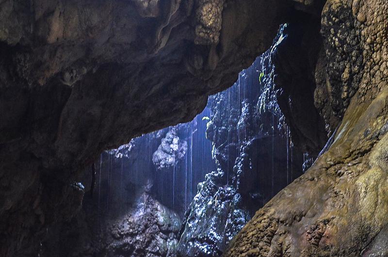
This cave does get a few of visitors, although not as many as Mawsmai Cave. At the beginning, it’s a much wider and more spacious cave than Mawsmai and with a higher ceiling, making it altogether less claustrophobic. However, it does get narrower and tighter as you proceed deeper into the cave. A stream runs through the cave so you’ll feel like you’re walking upstream along the river.
The cave is notable for its fossils, which are abundant within the cave and found imprinted all over the walls and ceiling of the cave. The fossils were left by gastropods and other marine creatures, indicating that this area was once underneath the ocean!
Mawmluh Cave
This is said to be the 4th longest cave in India and is over 4.5km in length with 5 different river passages. The cave entrance is found at the base of the western flank of Lum Lawbah (Lawbah hill), near the Mawmluh-Cherra Cements factory, which is located about 5km to the southwest of Cherrapunji.
We didn’t even know about the existence of this cave when we visited Cherrapunji. It’s a completely wild cave, that hasn’t yet been tamed for tourist visitors and exploring it will involve more of a mini-expedition.
Getting there:
You can get to this cave by first following the Sohra-Laitkynsew Road out of town until you reach the cement factory.
A river flows out of the cave and one of the cave entrances can be reached by following the river upstream until it disappears underground. However, reports suggest that this entrance requires wading through water during the wet season and wading through dangerous dry quicksand during the dry season.
There is a better entrance to the cave system higher up on the hillside, reached by hiking uphill through long grasses and vegetation. It may be difficult to find though, so it may be a good idea to have a guide if it’s your first time.
Additional Info:
It seems that most people explore this cave with a guide or within a small group where at least one person knows what they’re doing. It’s quite a serious undertaking.
Reports suggest that the cave is quite complex with many winding passageways and that it’d be quite easy to get lost if you weren’t paying attention to the landmarks.
There are sections that require wading in cold deep water (more than thigh-deep) and during the monsoon season the cave might be completely flooded with water and impossible to navigate.
There are also sections that require climbing up and descending down steep cliff faces, although none are particularly high. Ropes may be needed for some sections.
Within the cave, there’s the chance to witness beautiful limestone features, including stalactites, stalagmites, pillars and others. Bats are definitely living in the cave and blind cave fish may also be present.
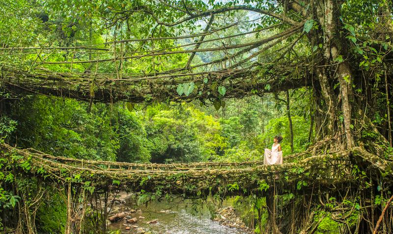
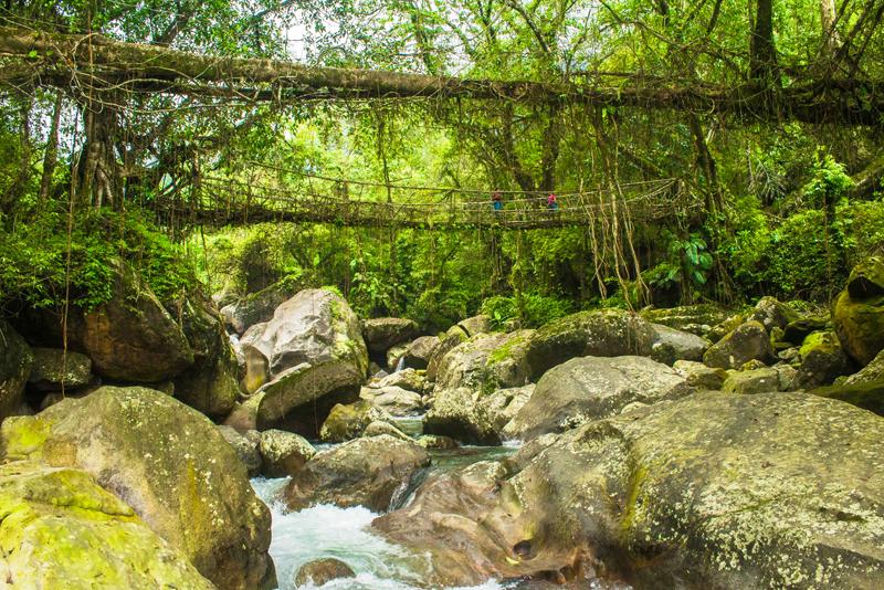
Seeing the root bridges
The living root bridges are absolutely unmissable if you’re planning to pay a visit to Cherrapunji. There are numerous examples of living root bridges found throughout the hilly regions of Meghalaya but very few of these have ever been seen by the outside world, let alone formally surveyed, photographed and documented.
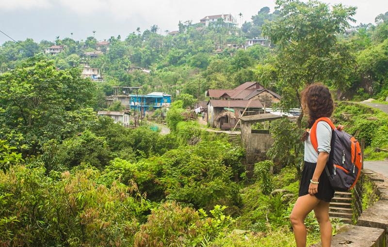
East of Cherrapunji for example, there are living root bridges to be found in the Khatarshnong region, in and around several villages including Nongpriang, Sohkynduh, Rymmai, Mawshuit and Kongthong and most likely several others.
In the East Khasi hills where Cherrapunji lies, root bridges can be found in and around the villages of Tynrong, Mynteng, Nongriat, Nongthymmai, Laitkynsew and others.
Mawlynnong (the cleanest village in Asia) has a very famous one that attracts hordes of tourists each year and what’s assumed to be the longest one in existence is found near the small Khasi town of Pynursla; this one is allegedly over 50 metres in length! However, nobody can confirm with certainty that this is actually the longest since a comprehensive investigation of the root bridges has not yet been carried out.
For those visiting Cherrapunji, the most accessible root bridges are those in and around the small Khasi villages of Nongriat and Nongthymmai, which are very near each other. We counted at least 5 living root bridges when we explored these two villages and their surrounding areas.
Getting to Nongriat (and Nongthymmai)
To reach Nongriat, you have to first get to the small village of Tyrna, which lies about 12km southwest of Cherrapunji, about 800m off the Sohra-Laitkynsew Rd. There’s an obvious junction where you have to turn off the main road to get to Tyrna.
Nongthymmai is a small village that you encounter en route to Nongriat, which features a beautiful living root bridge.
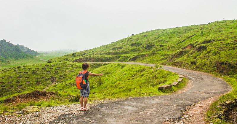
There is a daily local bus from Cherrapunji to Tyrna that leaves early in the morning but it doesn’t run on Sundays unfortunately. Ask around for the exact bus time. We actually needed to go on a Sunday so we just hitchhiked to Tyrna. It wasn’t long before some Indian businessmen picked us up in their car; they were apparently headed to the Bangladesh border for business purposes.
From Tyrna, just ask local people to direct you towards Nongriat as you walk through the village and eventually you should end up at the top of some concrete steps that lead down into the valley. Once you reach here, there are about 3,000 steps and 3.5km of walking between you and Nongriat. There’s no road; you simply have to walk the remaining distance.
Some sources claim that this is an extremely challenging, arduous trek but if you’re fit you probably won’t find it very challenging at all. After all, it’s downhill for most of the way. There’s another trek from Nongriat back up the valley to the Nohkalikai falls viewpoint that very few people attempt and THAT could be considered challenging by most people’s standards.
A short description of the trek to Nongriat
.jpg)
The concrete staircase from Tyrna village descends steeply into the valley, with lush forest cover on either side.
Beautiful wildflowers, butterflies and other wildlife abound on either side of the stairway to help you stay in high spirits during the long descent.
Local villagers also use the stairway and are often seen transporting heavy loads up and down the valley, without a word of complaint.
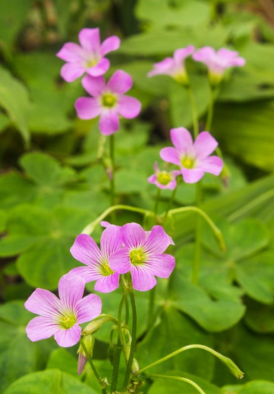
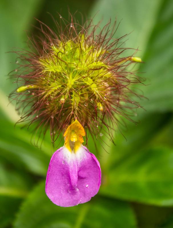
On the way down you might just catch a glimpse of the beautiful flowers of pink woodsorrel (Oxalis debilis).
The leaves of this plant are totally edible and they have a very pleasant sour taste, like apple peel, due to their oxalic acid content. Note that you shouldn't eat too many!
Even macaque monkeys love to munch on the leaves as we recently discovered.
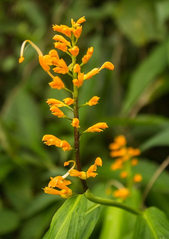
Other fantastic flowers we passed on the way were the beautiful pink flowers of bracted balsam (Impatiens bracteata), a plant that's mainly only found here in Meghalaya and further down towards the bottom of the valley in the shade of the forest, we found the beautiful yellow swan flower (Globba andersonii), which is a member of the ginger family. The flowers really do resemble swans!
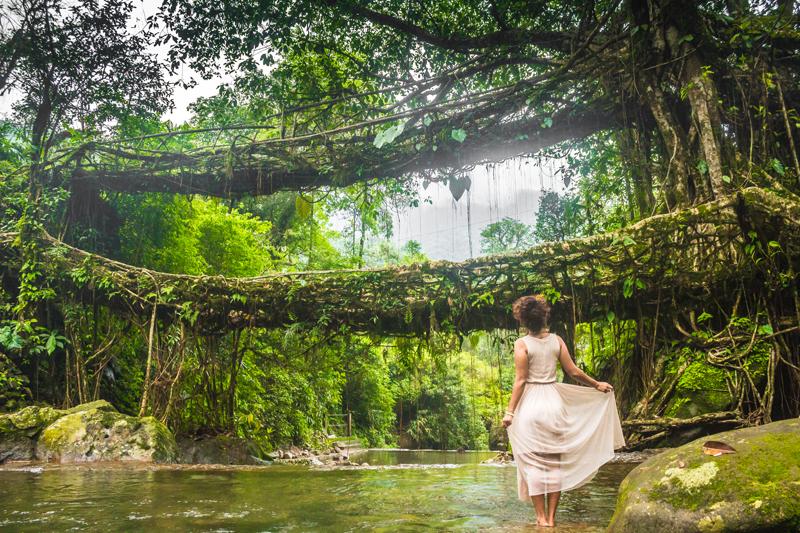
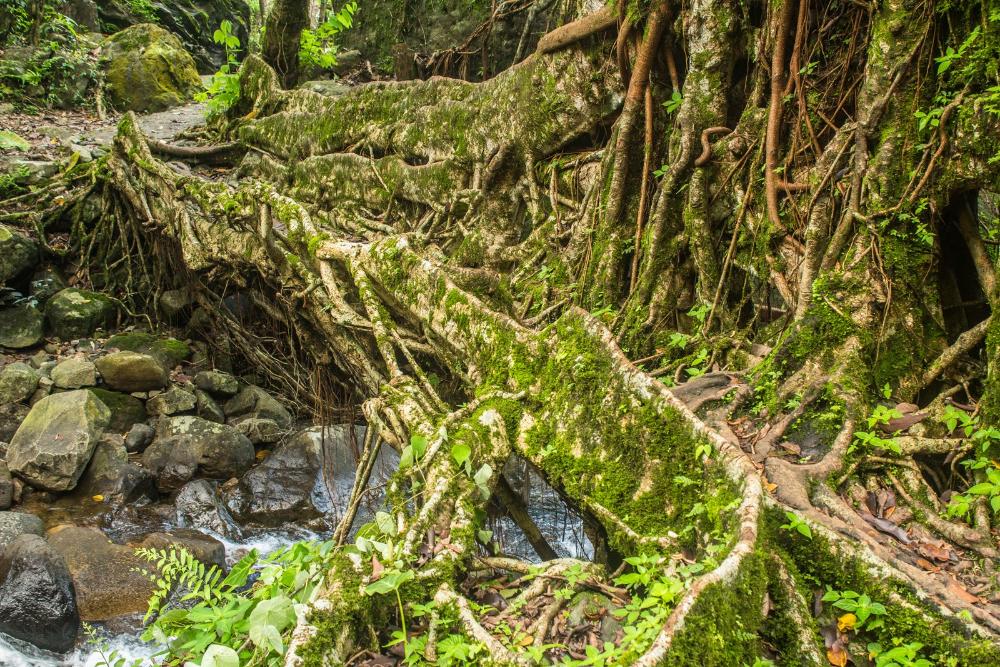
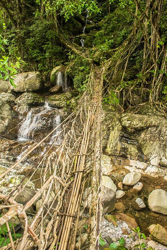
When you eventually reach the bottom of the valley, you’ll have reached the small village of Nongthymmai, where a short detour from the main trail brings you to a superb root bridge spanning a pristine river that tumbles down through a boulder-strewn river bed:
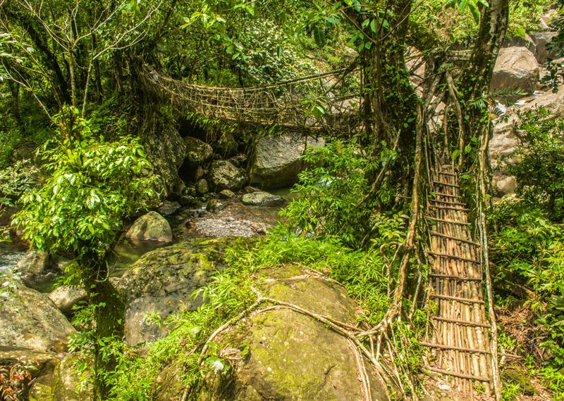
The bridge is remarkably strong and you can walk across it no problem without fear of it collapsing. Many of the living root bridges are actually built to be able to hold over 50 people at a time.
Not only are these bridges strong but they’re also far superior to artificial steel cable suspension bridges and bamboo bridges, which both weaken and deteriorate over time in this damp environment and hardly last 40-50 years.
Living root bridges on the other hand are not prone to decay from factors like rust, insects and fungi and will last for centuries and actually become stronger and more reliable over time.The result is that these natural bridges are virtually maintenance free and mechanical failure is extremely rare. They're an engineering model for mankind to aspire to in the future.
The bridges are also literally alive, like all the other elements of this ecosystem and are a fully integrated part of the forest. There is no sense of incongruence between the bridge and its surroundings, as would be the case with an ordinary man-made bridge. There is in fact hardly anything about them that seems man-made.
Seamlessly blending its environment, the bridge supports mosses, epiphytes (plants that grow on other plants) and an array of insects, just like any tree of the forest does. We saw ants scuttling along the bridge and it must be an excellent way for them to traverse the river and explore new territories without getting drowned.
The river that rushes beneath the bridge is also a fabulous place to take a cooling dip or a enjoy an invigorating swim upstream against the current in one of the many pools, if you don't mind some extra exercise!
We found a good pool to swim in just a little downstream of the bridge and looking back upstream at the bridge from here, we noticed there was what seemed to be a second younger root bridge that was in the process of being constructed.
The root bridges are made from the Indian rubber fig (Ficus elastica) and this species is selected for its interesting quirk of producing secondary roots from its upper trunk, which then seek to anchor themselves to a nearby object.
The process of constructing the root bridges involves channeling the young secondary roots into a hollowed out areca palm (Areca catechu) tree that is laid across the river on a supporting bamboo scaffold. The roots grow through this tunnel until they eventually attach themselves to the other side of the river.
More roots are later woven into the structure as it becomes stronger and handrails are also added. Gaps between the roots are plugged with soil, rocks and sticks. The supports eventually decay away in the wet climate, while the bridge continues to grow in strength and thickness.
The entire process usually takes between 10-15 years to establish a functional living root bridge. The long time it takes to create one of these bridges is their only real downside. However, the Khasi people certainly seem to believe its worth the wait.
After soaking up Nongthymmai for a while, you have to backtrack a little to the main trail and keep heading on towards Nongriat.
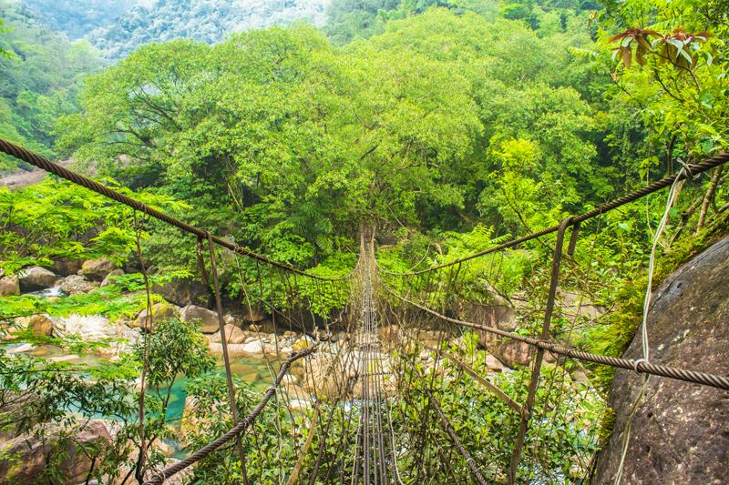
The next point of interest during the trek is an encounter with a wide river, spanned by a bridge made from several rusting steel cables. There is no choice but to put your faith in this dubious looking bridge. If only it were a living root bridge, there would be nothing to fear!
As you begin to venture across the bridge, clutching at the steel cables at eye level on either side, the entire structure swings from side-to-side and bobs up and down despite your best efforts to steady it. The raging river tumbles by underneath your feet and you may find yourself praying the bridge doesn’t give out. It’s an awesome experience though and very enjoyable.
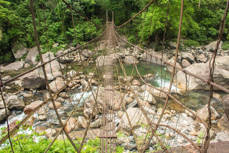
A little further on, you come to yet another river, this one split into two channels and with not one but two suspension bridges to cross! Again it’s just a matter of taking your time and looking straight ahead if you have a fear of heights.
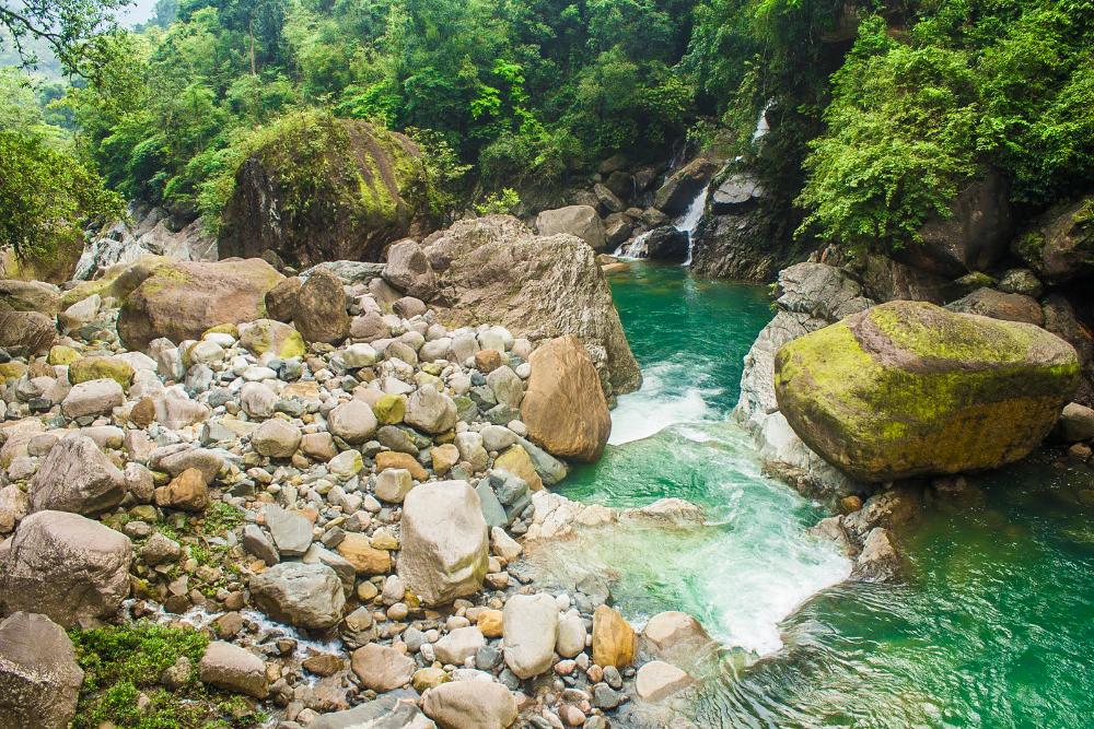
The river here has beautiful turquoise-coloured pools and the bed is strewn with many impressive boulders, especially in the stretch just downstream from the suspension bridge.
Once you’ve crossed this final hurdle, you’ve almost reached Nongriat. Before you continue on towards the village, pause for a brief moment to look down upon the bridge that you just crossed from the viewpoint above. It’s an opportunity for a spectacular photograph.
You now have to climb up steps for 15 minutes or so until you reach the village. Just before coming into the village, we crossed a very short root bridge, which looked incredibly sturdy:
Nongriat practicalities
Once you arrive in Nongriat, we highly recommend you stay a night or two here, because there are more root bridges and the spectacular Rainbow waterfall to be seen by doing day hikes around the village.
As for where to say, there is Serene Homestay, where most travellers seem to stay, but this is odd because our impression of the owner was that he seemed to be a bit rude.
We advise you to stay in the community-owned resthouse on the other side of the river, reached by crossing the double-decker living root bridge. Both of these will cost around 250 rupees per person per night. There was also a third option for about 100 rupees per night in a very basic wooden home with few facilities, offered by a woman at the village.
Meals are prepared by the homestays and each morning for breakfast we usually had porridge while in the evening we had very tasty dinners, usually consisting of steamed rice, dahl, vegetables and an omelette. You can also order a few other basic foods like egg maggi (egg cooked with noodles) at a hut just below the main village. There are also a few basic shops in the village selling snacks like crisps, cake, cookies etc. but they were quite overpriced.
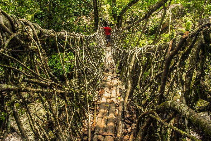
The double decker root bridge
.jpg)
The double decker root bridge is reached by veering towards the right beyond Serene Homestay and there’s a trail that takes you to it. You may or may not have to pay an entrance fee but probably will be asked to if you’re a foreigner.
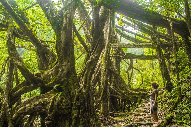
This bridge is a truly spectacular sight to behold when you see it before your own two eyes and a marvelous playground for photographers. This is a more mature bridge than the one at Nongthymmai and like the other root bridges, orchids and other epiphytes grow from it while younger pendulous roots dangle from the larger roots that span the river.
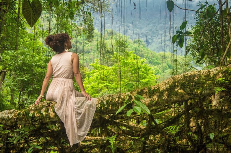
As if two levels weren’t already impressive enough, the local people are already in the process of adding a third level to the bridge, which should be completed in another 10 years or so.
In fact, there may already exist a triple-decker living root bridge in Meghalaya. There are also known root bridges with two parallel spans, found in the west Jaintia hills near the villages of Padu and Nongbareh. There are dozens if not hundreds more living root bridges in existence than the limited few that appear on google images.
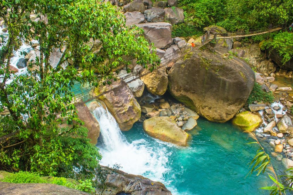
There is a small waterfall directly below the double-decker root bridge and another a short distance upstream from it. Indian tourists love to cool off here in the water so pick your times right if you want pristine photographs.
.jpg)
Some people just briefly visit the double-decker root bridge and then trek back to Tyrna, which is an incredible shame, because then they miss the other amazing nearby root bridge, which is found on the way to the incredible three-tiered rainbow waterfall.
The trek to rainbow waterfall
If you stay overnight in Nongriat, you have the perfect chance to trek to rainbow waterfall on day 2. The trek to the waterfall takes about 1.5-2 hours and begins on the far side of the double-decker root bridge where you just start following the path into the jungle.
The first point of interest on the walk lies a short distance from the village where there’s a big open field, at the end of which you again pick up the trail. You soon pass by a huge rock overhang and after this the path eventually brings you to the river, where there is yet another steel cable suspension bridge to walk (or bounce) across.
This one is really spectacular, with the lush green forest all around and the cerulean blue waters of the river below. After conquering this, there is yet another bridge that spans another channel of the same river and this second bridge is a kind of hybrid between a steel cable bridge and a living root bridge; steel cables are intertwined with the roots.
There are several small waterfalls ahead, where a small stream is tumbling down the steep valley slopes to feed into the main river.
After you make it across this rather long ‘hybrid’ bridge, you end up in a scene that’s straight out of a fairytale.
The rubber fig trees create an incredible display here, with their thick branches stretching out across the path overhead and attaching themselves to the adjacent slope.
You’re now on the correct side of the river to see the waterfall. You now have to continue walking upstream for quite some distance if you want to reach rainbow waterfall. As we recall, there is a sign somewhere near here that should help point you in the right direction as the trails can be a little confusing. Note that the path doesn’t cling to the riverbank the entire time and by following the trail we were forced to climb up the slope away from the river, especially as we neared the waterfall.
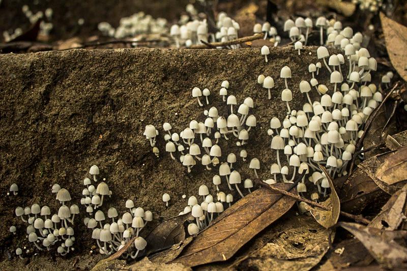
During the trek we spotted several varieties of colourful birds up high in the treetrops and a few huge colonies of fungi just like this one:
There were also exquisitely colourful butterflies fluttering around at every twist and turn of the trail. We found one floating in a stream, which was unfortunately dead. It may have been a Danaid eggfly (Hypolimnas missipus) with the colours washed out:
.jpg)
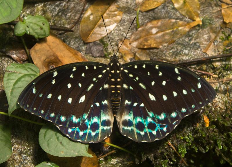
Another favourite was this female dark archduke (Lexias dirtea khasiana) laying low on the forest floor, with its magnificent spotted wings and turquoise hues:
Other butterflies we saw were the Fluffy Tit (Zeltus amasa), the Orange Staff Sergeant (Athyma cama), the Dark Blue Tiger (Tirumala septentrionis), the Orange Oakleaf (Kallima inachus), the Common Mormon (Papilio polytes) and a few other varieties. You can see more of the butterflies if you watch our Cherrapunji video at the end of the article.
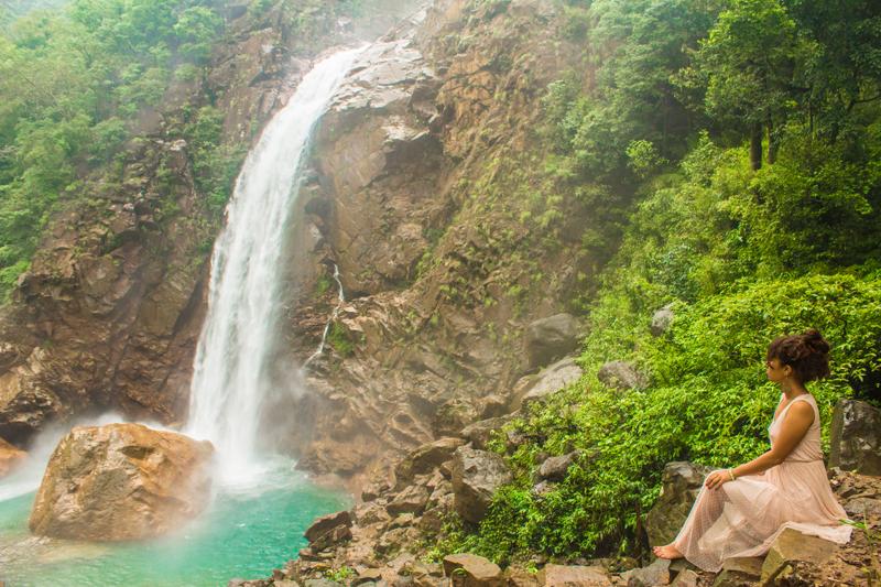
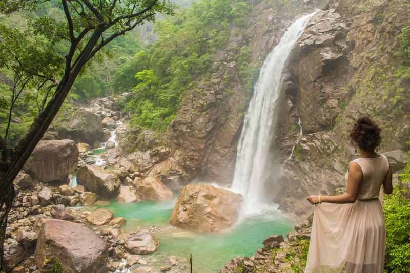
The final stretch to rainbow waterfall is actually a descent, because the trail brings you up high and away from the main river. During this final descent, you can see the three tiers of this spectacular waterfall through the trees, in all its glory.
The waterfall actually results from a tributary river, which tumbles down three cliffs before joining the main river. Of the three cascades, the final plunge to the main river below is the highest and the most impressive.
.jpg)
Upon seeing the waterfall, our hearts leapt with joy and amazement and we rushed down the trail to get to the viewpoint that appeared in the distance:
From here, as if by magic, there was an almost perfect view of the waterfall and the river valley off to the left, with no obstructions and nothing to mar that perfect shot.
We decided to descend towards the waterfall and followed the path carefully all the way down to the rocks near the foot of the waterfall. Down here, the waterfall becomes deafeningly loud and the misty spray really fogs up your camera lens and keeping it water-droplet free is very challenging indeed!
We investigated the possibility of swimming in the turquoise-coloured pool below the waterfall but decided eventually that it was too risky to try to get down into the river from here. There was no easy route down without jumping and the rocks were incredibly slippery, so much so that we wouldn’t advise anyone to walk on them.
After thoroughly enjoying our hike and visit to rainbow waterfall, we headed back to Nongriat village and stayed a final night at the homestay.
From Nongriat you don't necessarily have to return to Cherrapunji via Tyrna. If you're feeling adventurous, there's a challenging route leading up to the Nohkalikai Falls viewpoint on the plateau above.
It's a long hike that'll take you several hours and it involves about 700 metres of ascent. The route is pretty wild, with no villages and few signs of man; just you, the forest and thousands of steps; not for the faint-hearted.
We found the hike tough but very rewarding when we finally reached the top of the plateau after what seemed like an eternity. It was a surreal experience transitioning from the lush, humid green forests of the valley below to the bleak, foggy moorland of Cherrapunji. We highly recommend it if you're fit and capable.
Watch video:
Final thoughts
Cherrapunji is a unique and incredible place. We have visited countless destinations over the past few years but Cherrapunji has to be one of our all-time favourites.
The sheer majesty and untainted wildness of its landscapes and its breathtaking natural wonders and cultural treasures will leave you hungry for more. We were truly sad to leave Cherrapunji but we would surely return in a heartbeat to explore more of it.
Recommended Guidebook: Lonely Planet India
If you enjoyed this guide or found it useful, please share it and leave us a comment below. Tell us your thoughts or ask us a question. Are you planning a trip to Cherrapunji?
Pin this article!

JOIN OUR LIST
SUPPORT US
FOLLOW US
ABOUT US
Our names are Eoghan and Jili and we hail from Ireland and India respectively.
We are two ardent shoestring budget adventure travellers and have been travelling throughout Asia continuously for the past few years.
Having accrued such a wealth of stories and knowledge from our extraordinary and transformative journey, our mission is now to share everything we've experienced and all of the lessons we've learned with our readers.
Do make sure to subscribe above in order to receive our free e-mail updates and exclusive travel tips & hints. If you would like to learn more about our story, philosophy and mission, please visit our about page.
Never stop travelling!
FOLLOW US ON FACEBOOK
FOLLOW US ON PINTEREST
